

Hiking Mt.Dinara
Mount Dinara is part of the Dinaric Alps (also called the Dinarides), one of the most rugged and extensively mountainous area of Europe that extends over Slovenia, Croatia, Bosnia and Herzegovina, Serbia, Montenegro and Albania. The Dineric Alps are in fact named after Mount Dinara, a huge massif located on the border of Croatia and Bosnia and Herzegovina. Mount Dinara has two prominent peaks: Troglav (located across the border in Bosnia and Herzegovina at 1913 m high) and Sinjal (or just “Dinara”) which at 1831 m is the highest peak in Croatia.
When the guys (Goran and Vedran) asked me if I wanted to hike Croatia’s highest peak I had to say yes. We had previously been up Sveti Jure on Biokovo, the 3rd largest peak in Croatia at 1762 m. Biokovo had been incredible, the views fantastic. But we had driven up Biokovo – Mount Dinara is even higher and we would be climbing it.

We were joined on this trip by Dennis. Like us, he and his wife had retired a few years ago and were travelling around the world. This was his first time in Croatia and Dinara would be his first Croatian hike.
Location: Mount Dinara is located inland, close to the border with Bosnia and Herzegovina. The easiest route up was the one we were taking: from Glavas near the town of Kijevo. Expect 4-5 hours one way to the top using this route (the other popular route is from the town of Knin, this route takes about double the time).

It takes 1 ½ hours from Split, a drive through the Dalmatian hinterland that gets very scenic when you pass the town of Sinj. You’ll be passing Peruča Lake, a huge artificial (dammed) lake in a valley. On both sides of the valley are high, barren mountains.
Glavas was the starting point for our hike. The most prominent landmark at Glavas are the ruins of a fortress (Glavas Fortification). You see them before even arriving at the parking lot. Other than that there is a blue shipping container which is a hiking shelter (and which has a fire pit – we would cook a barbecue here at the end of the hike).


.
The early going of this hike was a steady, consistent climb on a rocky path through trees and shrubs. About an hour into our hike the trees and shrubs gave way to barren rock shrouded by grass (below).

We continued, the meadow-like terrain broken by a few steep ascents, then reverting back to a steady, consistent hike through grass. In some ways this monotonous, constant incline was even more tiring than other mountains characterized by steep, rocky climbs.
2 ½ hours into our hike we stopped for a break at the Martinova Kosara shelter, a stone hut built by shepherds.


.
The last half hour of the ascent is the most scenic. We walked along a ridge, views of mountain ranges in all directions. From there we climbed a last rocky incline. We arrived at the top.
Total time to the top: 4 ½ hours.
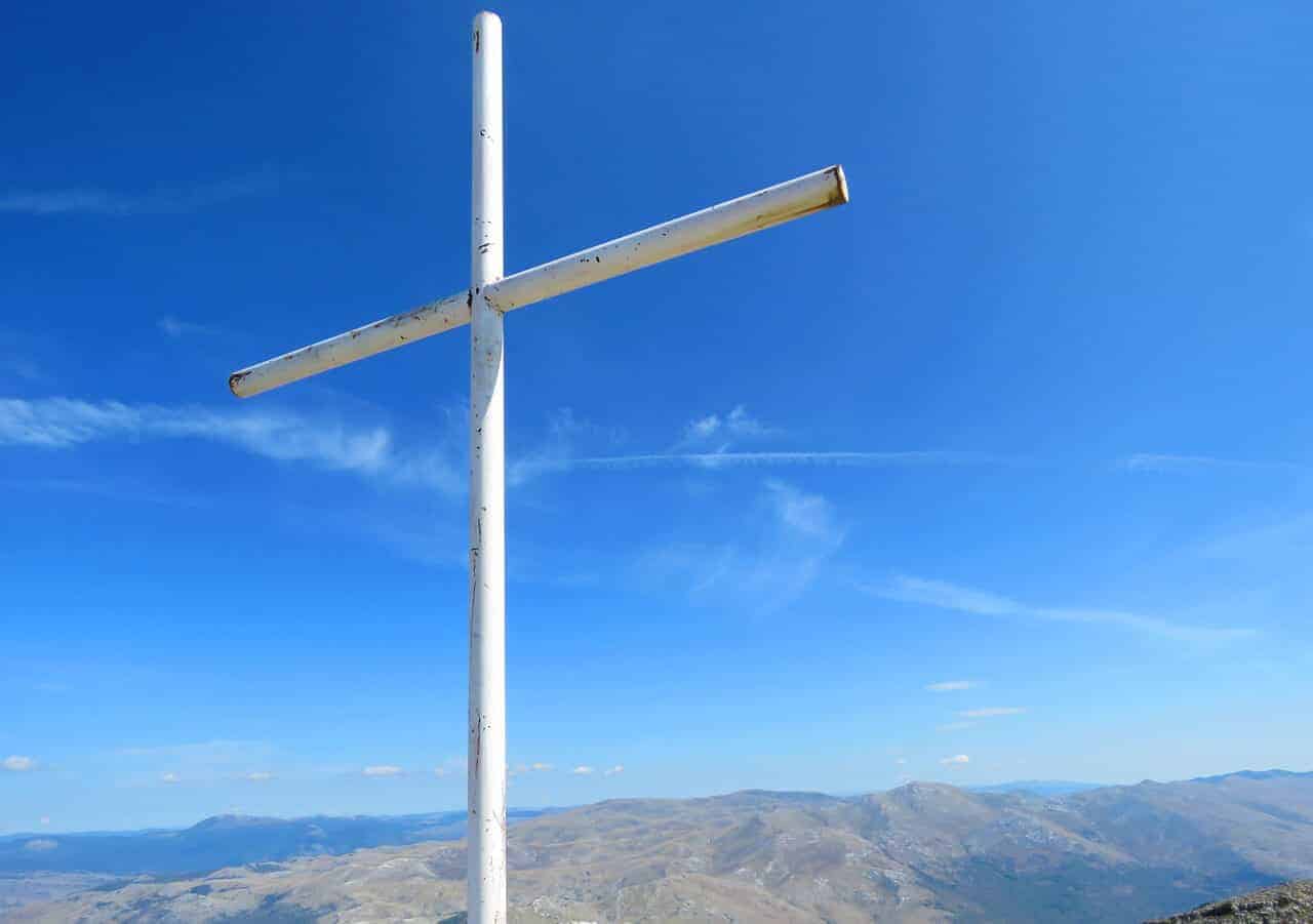
Below: Views at Dinara Peak (also called Sinjal Peak). 1,831 m.
(don’t forget to sign your name in the book located in the metal box).


We saw these dogs at the top and figured that they belonged to other hikers. They didn’t. They befriended us and would end up walking the 4 hours down the mountain with us.


Total time coming down: 4 hrs, 15 minutes (with time exploring the fortifications)
.
Below: We ended up cooking a barbecue at the Glavas Hiking Hut (it was Christmas for that dog – we gave him about 5 pork chops).


.
Notes on the Hike
– It is not a technically difficult hike and we never had to use hands to climb or scramble. But it is a constant, unrelenting incline that requires good fitness (total hiking time was close to 9 hours). You would have thought that coming down would be easier but it wasn’t – the path is full of loose rocks that requires you to always keep an eye on your footing.
– Wear boots. I wore running shoes and they got seriously beat up. The terrain here is really rough with some really jagged rocks, worse than any hike I’ve previously climbed in Croatia.
– There are some beautiful views of the Dalmatian hinterland and, up higher, of the mountains of Bosnia and Herzegovina. This is quite a remote area and except for the town of Knin (which you can see from the summit) there are very few signs of civilization.
– We did this hike in mid-September which is a perfect time to go. Summer is too hot and – here in the interior – winters are harsh. It is not recommended to hike Dinara November to April.
– If you get stuck in bad weather, the Martinova Kosara shelter is always open. But it is very, very basic with few of the amenities that you find in some of the mountain shelters on other mountains.
– More on this Mount Dinara and different routes here.
Highlights for us?
– beautiful views, good company (Dennis was a nice addition to the group), good food – we brought lots of meat and some beer and kept it in a cooler in the Glavas parking lot. The shelter has an outdoor cooking pit and we cooked it there when we finished our hike.
– the main reason to do this hike? To say that you’ve just climbed the highest peak in Croatia.

Related: Hiking Mount Mosor (Split, Croatia)
Related: Travel Bloggers on their favorite hikes around the world

Hi Frank,
I am enjoying your blog (or whatever it is called these days) as I am preparing my trip to Croatia. Is there any other mountain two hours drive from Split that you would recommend? I don’t mind walking 10 hours but Dinaria seems to be a bit boring. I don’t know if saying that I’ve climbed the highest peak in Croatia is worth the hassle. I don’t mind hiking a smaller peak but with more thrilling views or path to the top 🙂
Hi Marcin,
How about Kozjak (easiest to get to) or Mosor?
If you really want a challenging hike, go to Makarska (about 90 min by bus?) and climb up Biokovo. We drove it a few years ago. Gorgeous.
You’re right, Dinara not the most interesting hike plus hard to get to.
Thank you so much for all those amazing information! I am looking forward to my vacation and my hike!
Thank you Nancy. If ding this hike let me know how it went. Be warned though that summer not the time to do it, sun too hot.
I’ve got a few other Croatian hikes on the blog that might be more suitable.
awesome pictures!
Informative post, Thanks for sharing!
Thank you Sofia 🙂
I love hiking, so it would be great to hike up the highest mountain in Croatia…particularly since it looked so remote, beautiful and peaceful. It does look hard going …9 hours of hiking is gruelling, I bet you had some very achy muscles for days afterwards? After I climbed Mt Snowdon in Wales I could hardly walk for days afterwards 🙁
It was actually my knees that hurt Gilda from coming down – it was so rocky and slippery that you really had to plant each foot which put a lot of pressure on the knees. I think that factor was actually worse than 9 hours of hiking (which as you say is grueling in itself).
I remember your post on Mt. Snowdon. Good memories of Wales Gilda? I’d really be interested in visiting one day…
Looks like a full and beautiful day. And I am sure the Jack didn’t hurt.
The Jack never hurts and believe it or not does provide an energy surge. Like a Redbull but tastes better 🙂
It was a great day and company (including our 4-legged friends). The means of hydration was a little unusual but a pleasant surprise. I studied the mountain range a little before the adventure but I really appreciate the sharing of greater detail in your post.
Was a great time Dennis and a pleasure to have met you! I hope you’ve had a chance to do a few more hikes over the last few weeks. So much beautiful geography in Croatia.
HaHa! Had to laugh at the Jack Daniels “for energy.” Looks like a great hike and what better reason to do it than for bragging rights saying you’ve climbed Croatia’s highest peak and seen some of its most magnificent scenery. Looks like the weather gods were with you and that you had a perfect day!
Thanks Anita. It was our first hike in a few months because the summer heat can be brutal in the mountains (we went mid-September). It WAS a perfect day, still got a bit of a sunburn though (the part not covered by that terrible bandana…)
looks like a wonderful hike – how awesome to get to visit ruins on route!
Yes, that was unexpected. It almost has a “Game of Thrones” quality sitting there looking out over the valley….
Jack Daniels, huh?
Absolutely beautiful photos! Coming down can be treacherous. While walking 350 miles on the Camino de Santiago in 2015 I had a nearly daily dialogue on the evils of uphill -vs- downhill. I’m still not sure which is the lessor evil of the two.
Did no one claim the dogs?
You’re right. In the last 30 minutes my knees felt like they were locking. I think we had to be so careful with the footwork (all the loose rock) that I was straining them.
No one claimed the dogs. When we came back down they just fell asleep next to each other at the barbecue area. The white one was scared of people, the brown one I think was her mother – but she was sweet and very social. I think they were wild. But they seemed well fed, at least during hiking season.
Nothing better than a super hike that is dog-friendly too! It looks like such stunning countryside and not crowded!
HA! I know that’s your thing Jane 🙂 The white dog was nervous around people, but the other one was super friendly and accompanied us for 4 hours on the way down, stopping and resting whenever we stopped. We figure that they live in town somewhere and when they see hikers they follow them up (hikers always have food with them). And then they come down with the last set of hikers that day. I’m a dog lover, it made my day.